Field health images can be compared with other important data layers, such as yield, to give farmers a deeper understanding of crop performance that they can use as they plan for the next season.
 How Next-Level Field Health Imagery Helps You See Beyond The End Rows

Dr. Keely Roth | The Climate Corporation
Reprinted with permission from The Climate Corporation blog:
Growing up on a farm in central Illinois, I remember being so very ready for spring to arrive. With temperatures finally warming, equipment would start rolling down the roads and through the fields as farmers began tilling the soil and planting the year’s crops. It was always an exciting time – and I still feel that sense of anticipation and new beginnings about planting time today.
In my role at The Climate Corporation, I now have the opportunity to advance digital tools that help hard-working farmers like you make the most of your inputs and investments. It’s a new season, with new decisions to be made, and data-driven resources can help create a more successful harvest come fall. Monitoring your crops’ health during the growing season from emergence to maturity is a critical part of ensuring a productive harvest. One of the resources that can help to make this possible is Climate FieldView™ field health imagery. Let’s take a closer look at this valuable resource and the benefits it can offer you.
Satellite and drone imagery provides deeper field scouting insights
On my family farm, we often walked the fields once the crops emerged to see what was happening. Although back then it was the best way to scout, it was also time consuming and, as the crops got taller and the weather got hotter, it meant we didn’t always go as far in as we should. Because you can’t walk the entire field, scouting without guidance might not be an accurate read of how your crops are progressing. Today, FieldViewTM field health imagery from satellites and drones can give you clear insights into every acre of your fields, making scouting so much more efficient and effective. Sensors on satellites and drones capture imagery over an entire field, giving you a full view of your field’s health from above. It’s a different perspective on your operation, and one that will help you better track your crops through the season.
Spot and address issues such as crop disease and protect yield
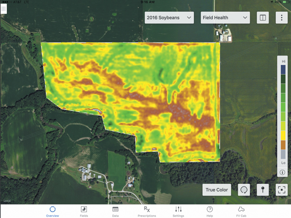
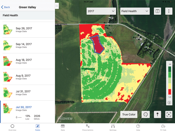
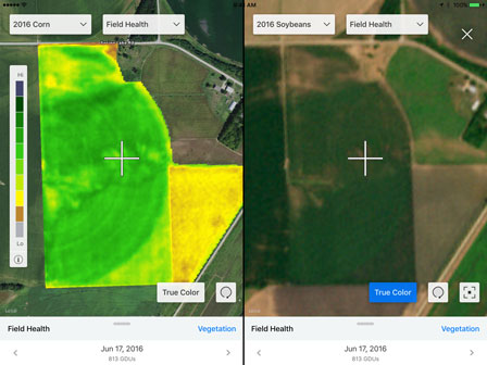
The biggest benefit of field health imagery is that you can identify and address potential yield-threatening issues with current and historical images. Using data collected by satellites and drones, the FieldView platform delivers three field health image types: vegetation, scouting and true color. Each of these layers offers a unique perspective of what is taking place in your fields.

Vegetation map
Monitor green biomass over time.

Scouting map
Spot and address potential crop health issues

True color map
Get a real-world view of your fields to compare to scouting or vegetation maps.
Field health images can be compared with other important data layers, such as yield, to give farmers a deeper understanding of crop performance that they can use as they plan for the next season.
What makes FieldView field health images unique is our proprietary science. The teams I work with develop methods to ensure that the images you see have the highest possible quality and accuracy throughout the growing season. Our process includes removing clouds and shadows to avoid interference that can distort the image. And because we know that later in the season, it can be difficult to distinguish vegetation differences, we engineer your images to better reflect variation in mid-to-late-season growth. Our goal is to make your images as representative of what is actually happening in your fields as possible.
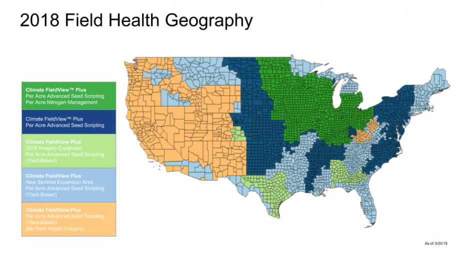
FieldViewTM satellite imagery availability in your area
More farmers than ever have access to this technology thanks to the latest expansion of FieldView™ field health imagery across a broader geography. If you've tried this feature before, it’s time to take a fresh look, as we have improved the experience over previous years with higher average resolution, better cloud detection, and enhanced algorithms for vegetation and scouting maps.

Advanced aerial imagery partners
To deliver deeper crop analysis tools and high-resolution imagery, the FieldView platform also integrates imagery from innovative aerial imagery partners, including:
Put the power of field health imagery and scouting maps to work for you
We live and farm in an exciting time, and field health imagery is just one example of the data-driven advancements that can help to make farming more productive. Check out some of the frequently asked questions, and discover how you can use field health imagery to uncover valuable field insights as part of your FieldView scouting strategy.
I wish you a successful planting season and hope you are as excited as I am to see those field health images begin appearing in your account! Your Climate FieldView dealer can consult with you to help you understand your field health images and what they are telling you about your field, or feel free to contact the Climate Support Team at (888) 924-7475 or support@climate.com.
About Dr. Keely Roth
Keely works on the Geospatial Research team at The Climate Corporation analyzing satellite and aerial imagery to provide better in-season field health insights to farmers. She earned a Master of Arts in Geography and a Doctor of Philosophy (PhD) in Geography and Remote Sensing from the University of California, Santa Barbara. She grew up on a corn and soy farm in central Illinois.
The content & opinions in this article are the author’s and do not necessarily represent the views of AgriTechTomorrow
Comments (0)
This post does not have any comments. Be the first to leave a comment below.
Featured Product

